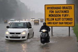
Hyderabad Braces for Sustained Monsoon Fury: Yellow Alert Extended Amid Heavy Rain Forecast
Hyderabad faces extended monsoon intensity with a yellow alert active until August 8. Expect heavy downpours, especially August 5-7, accompanied by thunderstorms and gusty winds. Local expert T. Balaji reinforces the forecast, predicting severe storms for surrounding regions and scattered intense storms within the city during afternoons/evenings, plus heavy night-morning downpours. The city remains vulnerable as recent rains (evident in Monday’s photos) have already caused significant waterlogging, saturating the ground.
Temperatures have plunged unusually low, with highs around 32.5°C recorded in parts of Hyderabad, likely dipping further. Residents must prioritize safety: avoid flooded streets, monitor reliable updates like IMD or Balaji, secure loose objects, and prepare for potential travel disruptions or brief power outages during storms. Stay weather-aware until conditions ease after the 8th.

Hyderabad Braces for Sustained Monsoon Fury: Yellow Alert Extended Amid Heavy Rain Forecast
Hyderabad is set for several more days of intense monsoon activity, with the India Meteorological Department (IMD) issuing a yellow alert valid until August 8th. The forecast predicts heavy to very heavy rainfall across the city and numerous Telangana districts, accompanied by thunderstorms, gusty winds, and the potential for localized flooding.
Key Forecast Details:
- Intense Rainfall Window: IMD Hyderabad forecasts heavy downpours specifically for August 5th, 6th, and 7th. This period carries the highest risk of very heavy rainfall.
- Extended Alert: The yellow alert, signaling “be aware” and the potential for localized disruptions, remains in effect for Hyderabad and surrounding districts through August 8th. While the peak intensity might ease slightly, significant rainfall and thunderstorms are still expected.
- Stormy Conditions: Residents should prepare for more than just rain. The IMD specifically warns of thundershowers accompanied by gusty winds throughout the alert period, increasing risks like falling branches or minor structural damage.
- Expert Echoes: Renowned local weather expert T. Balaji (@balaji25_t) reinforces the IMD’s warnings. He predicts severe storms for South and Central Telangana, with Hyderabad facing scattered intense storms during afternoon/evening hours and scattered heavy downpours very likely during night and morning periods.
Current Context & Impact:
- Recent Soaking: The city is already waterlogged in many areas following heavy rains on Monday, August 4th, as evidenced by widespread images of inundated roads. This saturates the ground, making flooding from additional rainfall highly probable.
- Temperature Dip: The relentless monsoon has significantly cooled Hyderabad. Data from the Telangana Development Planning Society shows maximum temperatures have plummeted, with Bahadurpura recording only 32.5°C – unusually cool for early August. Further dips are expected with the incoming heavy rain.
- Yellow Alert Meaning: This alert level urges residents to:
- Monitor weather updates closely (IMD, trusted local sources like Balaji).
- Expect possible disruptions to travel (waterlogging, poor visibility) and local services.
- Avoid waterlogged areas and underpasses.
- Secure loose objects outdoors.
- Be prepared for potential brief power outages due to winds or lightning.
- Postpone non-essential travel during intense downpours or thunderstorms.
Staying Safe in the Deluge:
Hyderabadis are advised to exercise heightened caution over the next few days:
- Plan Travel Wisely: Check real-time traffic and weather updates before heading out. Allow extra time and have alternative routes in mind. Avoid flooded streets completely – depth can be deceptive and currents strong.
- Stay Indoors During Storms: Seek shelter indoors when thunderstorms or intense downpours hit, away from windows.
- Charge Devices: Ensure phones and power banks are charged in case of outages.
- Clear Drains: If safe and possible, check nearby drains for blockages to minimize localized flooding near your property.
- Heed Official Advice: Follow any instructions from Greater Hyderabad Municipal Corporation (GHMC) or disaster management authorities regarding vulnerable areas or evacuation notices.
Hyderabad is in the grip of a potent and sustained monsoon phase. The combination of saturated ground from recent rains and the forecast for several more days of heavy precipitation, thunderstorms, and gusty winds significantly elevates the risk of urban flooding, travel chaos, and localized damage. Residents should treat the IMD’s yellow alert seriously, prioritize safety, stay informed via reliable sources, and take proactive steps to minimize disruption until the weather system eases after August 8th. Vigilance and preparedness are key as the city weathers this active monsoon spell.
You must be logged in to post a comment.